Understanding China’s Position on the South China Sea Disputes
ISDP
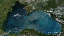
Rich in fisheries, potential energy resources, surrounded by rapidly developing states, and encompassing strategic transport routes, the South China Sea has become a focal point for territorial and maritime disputes with tensions having escalated in recent years. The main competing parties include China, several ASEAN states, notably the Philippines, Vietnam, and Malaysia, as well as the United States as an extra-regional power. The intention of this backgrounder is to clarify specifically China’s position and perspective on its territorial and maritime claims in the South China Sea, the causes for recent tensions over these claims, and the manner in which these disputes are to be managed and resolved.
Note: the views and opinions expressed in this Backgrounder do not necessarily reflect those of ISDP, which neither affirms nor rejects the validity of China’s, or any other party’s, standpoints.
China’s Basic Position
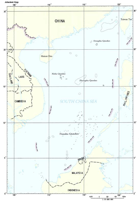
Beijing considers that the islands, banks, and shoals as well as surrounding waters of the Xisha, Nansha, Zongsha, and Dongsha archipelagos,[1] all the way down to the Zengmu Ansha reef[2] as its southernmost tip, constitute an indisputable and indivisible part of China’s historical territory. Together these territories account for hundreds of islands, islets, sandbanks, rocks, and shoals (also referred to as “maritime features”) throughout the South China Sea region. While Brunei, Malaysia, the Philippines, Taiwan, and Vietnam have overlapping claims in the region, the Chinese government deems alternative interpretations to its claims to be untenable.[3]
The geographical extent of the claimed area has variously been represented by 9, 10, and 11-dashed lines indicating the area China considers it has sovereignty over. The most recent version of these maps was circulated by China as a set of notes verbale to the United Nations in 2009 (see appendix, map 1).[4] Although the exact number and distribution of dashes has varied, the 9-dash map is largely seen to follow an 11-dash line map published by the Nationalist Government of the Republic of China in 1947 (see appendix, map 2). This map, in turn, is understood to reflect a map published by the Republic of China Land and Water Maps Inspection Committee of 1935. Indeed, as successors to pre-1947 China, both Taiwan and Mainland China exert highly similar claims in the South China Sea.
Despite these maps’ apparent focus on maritime delineation, it should be noted that what China’s claims actually emphasize is sovereignty over territorial features (i.e. islands) within the area demarcated by the dashed lines. As noted by a U.S. State Department document, the nature of maritime claims is as such of a comparatively lower priority and has been less precisely articulated. In fact, in 1996 China provided geographic coordinates which can serve as baseline for a formal maritime claim, but only did so for the Xisha (Paracels) and Diaoyu Islands[5] (in the East China Sea) – other South China Sea maritime claims remain as of yet unclarified. The importance attributed to territorial sovereignty, as opposed to maritime delineation, is reiterated in among other, the 2014 “Position Paper of the Government of the People’s Republic of China on the Matter of Jurisdiction in the South China Sea Arbitration Initiated by the Republic of the Philippines.”
Historical Basis of China’s Claims
China’s claim is rooted in its understanding that the territorial features of the South China Sea constitute territory over which China has historically held sovereign jurisdiction – that is, “ancestral properties” passed down from previous generations. In its abovementioned Position Paper, China expresses that “Chinese activities in the South China Sea date back over 2000 years ago” with China being “the first country to discover, name, explore and exploit the resources of the South China Sea islands and the first to continuously exercise sovereign powers over them.” For instance, Chinese sources claim that maps of the South China Sea islands were published throughout the Ming and Qing dynasties, including in navigational charts drawn up by China’s thirteenth-century admiral and explorer Zheng He.[6]
Chinese sources reiterate that Chinese possession of South China Sea islands has been acknowledged by a number of international sources throughout modern history. These include listings in, for example, British, (East and West-) German, French, and Soviet atlases of the area published in the 1950s and 1960s. Moreover, the Chinese government’s Position Paper highlights that territorial claims by other South China Sea claimants (notably the Philippines) did not encompass the marine features within the dashed-line area until the 1970s. From Beijing’s perspective, this suggests that other countries’ claims are relatively recent, politically motivated, and further incentivized by resource extraction.
Perceived International Recognition of Claim
According to its proponents, China’s claim stood relatively undisputed until the 1930s. From this time onwards, Western colonial forces and an increasingly assertive Imperial Japan recognized and sought to utilize the strategic value of the Nansha Islands (Spratlys) in particular. In 1939, Japan occupied parts of the archipelago in an attempt to control Southeast Asia and prepare for an invasion of Australia. Upon Japan’s defeat in 1945, it was stripped of the area it had occupied in the South China Sea. Although post-war ownership of the islands remains disputed, both Mainland China and Taiwan have adopted the position that rather than creating a “void,” the areas have been restored to Chinese ownership.
In this regard, Chinese sources repeatedly refer to the Cairo Declaration of 1943 and Potsdam Declaration of 1945. Together these declarations emphasize that areas once held by Japan in the South China Sea would no longer be part of that country’s post-war sovereign territory, and that “[…] territories Japan has stolen from the Chinese, such as Manchuria, Formosa, and the Pescadores, shall be restored to the Republic of China.” Ownership is deemed to have been implicitly accepted by Western powers (notably the United States) in their failure to object to repeated assertions by (initially) Taiwan over South China Sea sovereignty. As part of the Chinese claim, Taiwan has maintained a presence on Taiping Island (the largest island of the Nansha Islands Archipelago) since 1946. To Beijing’s understanding the status of the islands was seemingly acknowledged as Chinese territory through U.S. requests to the Taiwanese authorities for permission to perform aerial surveys in the region between 1957 and 1961.
How Does China View Responsibility for the Escalation of Disputes?
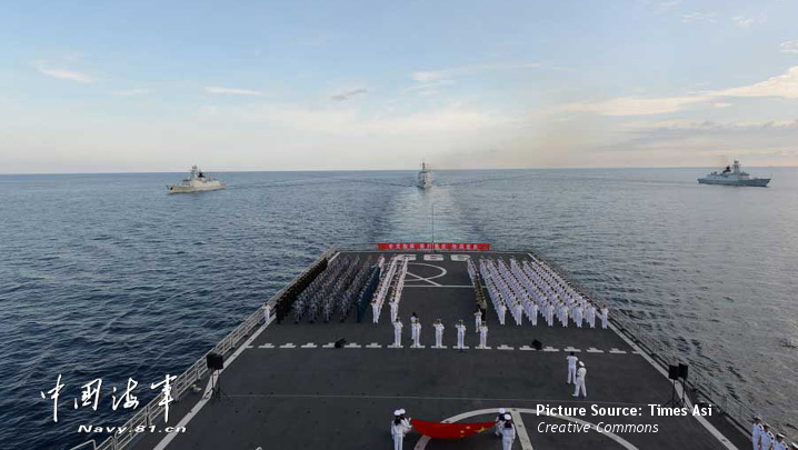
Much international attention has focused on China’s activities in the South China Sea, such as land reclamation, which have been seen by some as indicative of China’s increasing assertiveness and growing strategic posture. Beijing, however, lays the blame for the escalation of disputes on the “provocative” actions of the other claimant states as well as the increased presence of the United States in the region. More recent tensions and their escalation can be divided into three periods.
Starting in the 1990s, Wu Shicun and Fu Ying[7] in an article for The National Interest highlight that “a major development was a new wave of unilateral occupation of the Nansha Islands and development of oil and gas in surrounding waters by some countries,” particularly Vietnam and Malaysia. Furthermore, the actions of the Philippine Navy, for example, by intercepting Chinese fishing vessels, and in April 1997 demolishing a Chinese territory monument on Huangyan Island (Scarborough Shoal) and replacing it with a Philippine flag, are characterized as having shown provocative behavior. Notwithstanding, the development of China-ASEAN relations during this decade largely masked growing tensions, argue the authors.
These initial developments entered a new phase following the signing of a Declaration of Conduct (see section below) between China and ten ASEAN countries in 2002. Despite its signing, Wu and Fu argue that other countries, most notably Vietnam, failed to sufficiently abide by the document and continued to consolidate their “illegal” claims. China, by contrast, they argue, “kept pushing for peace and cooperation and joint development in disputed areas.” Indeed, rather than see itself as the aggressor, China’s Ambassador to the EU, Yang Yanyi, has argued that “China is the victim of the South China Sea issue.”
However, it was the announcement by the Obama administration of the U.S.’s rebalancing to Asia from 2010 onward[8] which many Chinese view as a turning-point in the escalation of disputes. By enhancing its regional military presence, the U.S. is seen to have “taken sides” and thereby emboldened the actions of the other claimant states. In a 2016 media interview, China’s Vice Foreign Minister Liu Zhenmin cites the 2012 Huangyan Dao incident (a spat with Vietnam over oil and fishing activity near the Paracel Islands) and the Philippines initiation of international arbitration in January 2013 as being indicative of this.
A particular bone of contention for China is the United States’ Freedom of Navigation program. While the U.S. defends its actions in the area, such as conducting marine patrols, as reinforcing international maritime law, China sees this as being used beyond acceptable limits as a pretext for damaging China’s security interests and violating its sovereignty. A case-in-point was the dispatching of USS Lassen which a Chinese foreign ministry spokesmen asserted illegally entered within 12 miles off Zhubi Reef on October 27, 2015.[9] It also sees the U.S. as trying to strengthen an alliance system and forces network around the South China Sea, such as through joint military exercises with the Philippines as part of a five-year Maritime Security Initiative and the lifting of a U.S. arms embargo on Vietnam (announced in May 2016). Accordingly, Beijing sees the U.S. as engaging in geostrategic competition with China, a rivalry it sees as exacerbating what are localized disputes with other claimant states.
Rather than locate the blame for escalating tensions on China’s building on reefs and islands starting on the Nansha Islands in December 2013, Liu Zhenmin emphasizes that China was the last country to carry out such construction and “was forced to react” to the changing regional situation to defend its interests. Furthermore, in an article for Xinhua news agency,[10] China’s activities are defended as follows: “many of the facilities are for civilian purposes … such as navigation and rescue services … and do not represent ‘militarization’ of the area.” A further key distinction made by the Chinese side is that construction by other claimants has been on Chinese reefs and islands that they have illegally occupied, while China’s construction is on features that have historically been China’s own sovereign territory.
How does China Envisage Management and Resolution of the Disputes in the South China Sea?
China together with other ASEAN countries is a party to the Declaration of Conduct of Parties in the South China Sea (DOC). Signed in 2002, all sides declared commitment to ten principles which include, among other, exercising self-restraint, environmental protection, marine scientific research, reaffirming commitment to principles of international law, and building trust and confidence. The 17th China-ASEAN Summit designated 2015 as the year of maritime cooperation in which all sides affirmed their commitment to “effective implementation of the [DOC] as well as to work towards the early conclusion of a Code of Conduct in the South China Sea based on consensus.” China has emphasized the necessity of full and effective implementation of the DOC from which it sees some parties as having deviated. It also believes the DOC has not been followed-up on by concrete negotiations about the content of any solution.
In terms of conflict resolution, China states that it prefers to resolve disputes peacefully with individual claimant states on a bilateral level rather than through arbitration provided by the UN or other forms of what it sees as “imposed” dispute settlement. Whereas China is a party to the United Nations Convention on the Law of the Sea (UNCLOS), it views its compulsory dispute settlement mechanisms as “inappropriate” and to which it has rightfully opted out (see arbitration case below). In Point 30 of the Position Paper issued in December 2014 by the Government of the PRC, it maintains that: “With regard to disputes concerning territorial sovereignty and maritime rights, China has always maintained that they should be peacefully resolved through negotiations between the countries directly concerned.”
While the United States is not party to the above agreements, confidence-building measures have been pursued between Washington and Beijing. In April 2014, both sides signed the Code of Unplanned Encounters on the Sea. This was followed in September 2015 by Presidents Obama and Xi signing an agreement on rules for military air-to-air encounters. Beijing asserts that the U.S. should not take sides, even if the official U.S. position is that it respects international law and takes no position in such third party disputes. Instead, Beijing calls for Washington to work with China based on “non-conflict and non-confrontation, mutual respect, and win-win cooperation.”
China further accedes to the principle of freedom of navigation and overflight – which it recognizes all countries are free to do under international law. Indeed, it asserts that maintaining these routes open in the interest of peace and stability is critical for China. However, it argues this should not be used as a pretext for undermining China’s sovereignty and security. And while China upholds territorial sovereignty, it has also not dismissed joint development of zones. While this has proven harder regarding oil and gas, China established a common fisheries zone with Vietnam in 2000.
China’s View on the Arbitration Case
In January 2013, the Philippines submitted a Notification and Statement of Claim in order to begin compulsory arbitration proceedings under UNCLOS over matters of “maritime jurisdiction” in the South China Sea. According to this notification, China’s assertion of ”historic rights” of the waters, sea bed and subsoil within the “nine-dash line” is in various ways inconsistent with UNCLOS, and has moreover interfered with what the Philippines regards as its sovereign rights, jurisdiction, and rights and freedom of navigation.
China believes the court has no jurisdiction to decide on the matter. As such, it rejects the case and will not accept or participate in the arbitration. As discussed in the Chinese government’s Position Paper, two reasons for rejection stand out. First, on August 25, 2006, China deposited, as permitted under Article 298 of UNCLOS, a statement that China will not accept compulsory dispute settlement procedures (including compulsory arbitration) concerning maritime delineation. Second, China rejects the court’s authority because, according to the Beijing, the Philippines’ argument is based on a “cunningly packaged” attempt to address matters of territorial sovereignty – not the legal status of disputed waters, islands, and reefs as the court is set to investigate. This conflicts with China’s standpoint that the matters of sovereignty and legal status are inseparable. Ultimately, the case, from China’s perspective, is not an attempt to attain peaceful resolution of the South China Sea issue, but rather a unilateral effort to force a resolution of the disputes on the Philippines’ own terms.
By recasting the case as one fundamentally challenging Chinese sovereignty over the Nansha Islands, China believes the case constitutes an infringement of Chinese territorial integrity. More than just an infringement of territory, the Philippines’ claim is seen to disrupt the unity of the Nansha Islands Archipelago, which, according to Beijing, constitutes a territory that cannot be divided on an island-to-island basis.
Key Sources
Andrew Browne, “The Danger of China’s Victim Mentality,” The Wall Street Journal. Published on 2016-06-14
Association of Southeast Asian Nations (ASEAN), “Declaration on the conduct of parties in the South China Sea.” Published on 2012-10-17
Bonnie S. Glaser, Michael J. Green, Gregory B. Poling, ”The U.S. Asserts Freedom of Navigation in the South China Sea,” Center for Strategic and International Studies (CSIS). Published on 2015-10-27
Fu Ying, Wu Shicun, “South China Sea: How We Got to This Stage,” The National Interest. Published on 2016-05-09
Isaac B. Kardon, “The Other Gulf of Tonkin Incident: China’s Forgotten Maritime Promise,” Center for Strategic and International Studies (CSIS), Asia Maritime Transparency Initiative (AMTI). Published on 201-10-21
Ministry of Foreign Affairs of the People’s Republic of China, “Position Paper of the Government of the People’s Republic of China on the Matter of Jurisdiction in the South China Sea Arbitration Initiated by the Republic of the Philippines.” Published on 2014-12-07
Ministry of Foreign Affairs of the People’s Republic of China, “Foreign Ministry Spokesperson Lu Kang’s Remarks on USS Lassen’s Entry into Waters near Relevant Islands and Reefs of China’s Nansha Islands.” Published on 2015-10-27
Ministry of Foreign Affairs of the People’s Republic of China, “The Minutes of the Meeting Between Vice Foreign Minister Liu Zhenmin and US Media Delegation on the South China Sea Issue.” Published on 2016-06-03
Ministry of Foreign Affairs of the People’s Republic of China, “Statement of the Ministry of Foreign Affairs of the People’s Republic of China on Settling Disputes Between China and the Philippines in the South China Sea Through Bilateral Negotiation.” Published on 2016-06-08
United Nations Convention on the Law of the Sea (UNCLOS), December 10, 1982.
United States Department of State, Bureau of Environmental and Scientific Affairs, “Limits in the Seas, No. 143, China: Maritime Claims in the South China Sea.” Published on 2016-12-05.
Xinhua, “China not to accept any act detrimental to security interests under navigation-freedom pretext: Xi.” Published on: 2016-04-01
Xinhua, “China, ASEAN have will, ability to safeguard peace, stability in South China Sea: Vice FM.” Published on: 2016-04-29
Xinhua, “How to Bridge the Divide Over the South China Sea.” Published on: 2016-06-08
Appendix
Map 1: Nine dash-line map of South China Sea claim, from notes verbale submitted to United Nations in 2009. Click the map for a larger version.
Source: United States Department of State, Bureau of Environmental and Scientific Affairs, “Limits in the Seas, No. 143, China: Maritime Claims in the South China Sea”. Published 2016-12-05. Page 2
Map 2: Eleven dash-line map of South China Sea claim, published by (Nationalist) Government of the Republic of China in 1947. Click the map for a larger version.
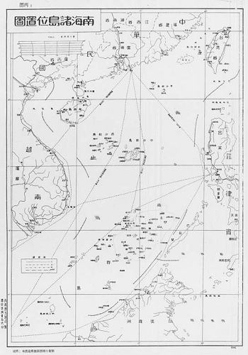
Source: United States Department of State, Bureau of Environmental and Scientific Affairs, “Limits in the Seas, No. 143, China: Maritime Claims in the South China Sea”. Published 2016-12-05. Page 3
Sources:
[1] These islands are also commonly known as the Paracels, Spratlys, Scarborough Shoal and Macclesfield Bank, and the Pratas Islands, respectively. Other claimant states also have their own names for these islands. To avoid misrepresenting China’s perspective, the Chinese names are primarily referred to in this document.
[2] Also known as the James Shoal.
[3] The Lowy Interpreter provides a good map showing the main sites of contention. See: http://www.lowyinstitute.org/issues/south-china-sea
[4] These notes were deposited in response to Vietnamese and Malaysian submissions to the Commission on the Limits on the Continental Shelf.
[5] Japan refers to them as the Senkaku Islands.
[6] ISDP has at the time of writing been unable to retrieve publishable copies of these maps.
[7] Fu Ying is Chairperson of the Foreign Affairs Committee of China’s National People’s Congress. Wu Shicun is President of the National Institute of the South China Sea Studies.
[8] Also known as the “pivot to Asia,” the policy involves repositioning 60 percent of overseas U.S. forces to Asia-Pacific by 2020.
[9] Under UNCLOS Article 3, a coastal state can establish sovereignty over adjacent waters, known as territorial seas, “to a limit not exceeding 12 nautical miles” from its coastline. This includes the coastline of offshore islands.
[10] Xinhua is the official Chinese government news agency.